The ‘smartest’ volcano
The very name of
Creator v/s destroyer
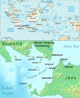
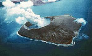
The Krakatoa has a unique and terrible history of continuous eruptions with devastative effects. The ‘Anak Krakatoa’ (meaning child of Krakatoa as this small island was born in an explosion of the Krakatoa Volcano in 1927!) is a small island standing nearby; along with this creation this volcano has split and sunk surrounding islands in the deep sea.
16,000 little boys!
To understand the real ferocity of its eruption a comparison would be of some use. The energy released in Krakatoa’s 1883 eruption was 16,000 times more powerful than the bomb that was dropped in
There are differences of opinion regarding the origin of its name; the most popular opinion is that; the word ‘Krakatoa’ was derived from Sanskrit word ‘karkataka’ which means crab or lobster a ubiquitous being of this island.
The clash of plates
As per geologists the Krakatoa islands are located just above a subduction zone of Indo Australian and Eurasian plates. Conflicts between these continental plates make the crust of the earth weak resulting in frequent geological disasters and volcanic eruptions.
Three islands
Krakatoa was initially a large land mass that got split into three islands, which were also destined to exist only up to the infamous 1883 eruption. These three islands and a tiny forested islet that were rocked belonged to the Krakatoa cluster were; Rakata Kecil (old name Lang), only a part of the island survived the eruption.
Sertung or Danan (old name Verlatan meaning deserted place) it was mostly destroyed in the 1883 eruption.
Poolsche Hoed (corrupted word for Polish Hat) was a forested little islet that stood nearby the Krakatoa. It disappeared in the 1883 eruption.
Three peaks
Along with these there are numerous rocky islets. The three volcanic cones are Rakata (the highest; height 823 meters), Danan (height 445 meters) and Perboe Watan (the smallest; height 122 meters) .
The
Pre eruption island
Only vague records are available regarding the people and conditions of the Krakatoa prior to the 1883 eruption. In 1780 the crew of HMS Resolution and HMS Discovery while returning to native land after the death of Captain Cook anchored their ships near Krakatoa and they have described the native people as friendly. The archaic Krakatoa Island that had a land area of about 9 km radius with a volcano with a 2000 meter height in its center. The past eruptions have split it destroyed it as well as enlarged it.
Pustaka Raja or Pararaton (king book)
Written in Kawi language in Saka Year 1481 or 1600 AD (Shalivahana or Kaka is an Era used in ancient Hindu and Cambodian Buddhist Calendar; its zero date begins in the equinox of 78). This rare book (a manuscript) in Kawi language (Kawi is a mixture of literary languages of Java and Bali with words of Sanskrit, Kawi is for Kavi = poet in Sanskrit) gives the details of 416 AD eruption of Krakatoa along with the history of Singhasari and Majapahit kings who rules the Eastern Java region.
First hand report
This book (The Pustaka Raja) has 32 folios and 1126 lines written in a style where facts, fiction and fantasy get intertwined. It contains the earliest written description about the terrible explosion of Krakatoa; “A thundering sound was heard on
A sample eruption!
The 1883 eruption was the most ferocious; its preparation began months before as seismic activities of the region reached its peak. A ‘sample’ eruption was orchestrated in
Cataclysmic stage
August 27 was the D day four tremendous explosions (3-30, 6-40, 8-20, 10-02) that rocked the whole area. The last was the worst its sound has the record of the loudest ever recorded on earth, the tsunamis it recorded were 100 feet high! The ash emitted to the height of 50 miles (80 km). No living things were left alive in the surrounding islands.
The volcanic ash that fell on the Ketimbang
The official records kept by the Dutch authorities report the total toll as 36417; how they collected this exact data is best known only to them! By 28th the volcano went silent. By that time the
Business as usual
In 1816 after the 1883 eruption one Dutch by name Johanan Handl arrived on Krakatoa with a right to mine the pumice from about 9 sq km area left after the blast. Four European families and thirty workers were part of the team. He resided in built house and garden in the southern part of the island. For two years until he left the island Johanan Handl was the ‘uncrowned king’ of Krakatoa! It is said that it was he who introduced the black rats in to this island.
Krakatoa now
The Volcano at Krakatoa never takes a long nap, goes on erupting intermittently a recent one was in 1994, in 2007 also saw it spitting gas and lava. This island is on a ‘growth path’ since 1950 as the lava and ash spit by the volcano fill the surrounding ocean the sea recede expanding the island area at 5 inches per week! For scientists Krakatoa is a laboratory for conducting their research on volcano logy.
Related Reading


No comments:
Post a Comment